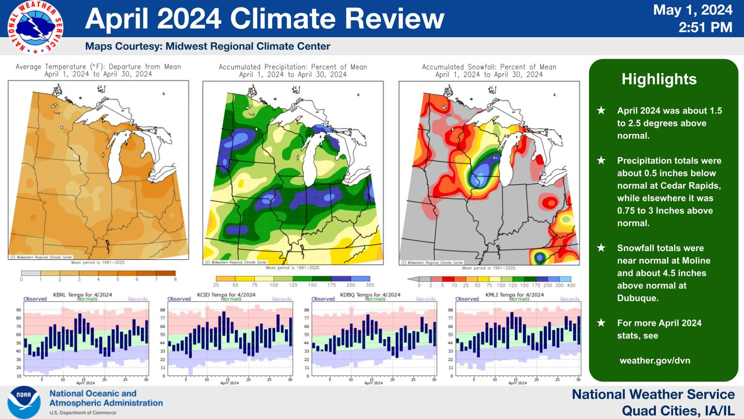
Weather

Weather Conditions at 06/24/2025 10:35:00 PM

Time: 06/24/2025 10:35:00 PM
Outside Temperature: 74.8°F
Inside Temperature: 79.7°F
Wind Chill: 74.8°F
Heat Index: 74.8°F
Dewpoint: -31.9°F
Humidity: 1%
Barometer: 29.964 inHg
Wind: 0 mph from N/A
Rain Rate: 0.00 in/h

Daily Weather Summary as of 06/24/2025 10:35:00 PM

Day: 24 Jun 2025
Min Outside Temperature: 71.5°F at 06:05:48 AM
Max Outside Temperature: 86.3°F at 04:49:41 PM
Min Inside Temperature: 79.6°F at 10:07:01 PM
Max Inside Temperature: 82.8°F at 11:51:01 AM
Min Barometer: 29.886 inHg at 03:40:02 AM
Max Barometer: 29.994 inHg at 10:18:03 AM
Max Wind : 8 mph from 146° at 02:56:42 AM
Rain today: 0.10 in

Monthly Weather Summary as of 06/24/2025 10:35:00 PM

Month: June 2025
Max Outside Temperature: 94.3°F at 06/11/2025 02:34:44 PM
Min Outside Temperature: 50.5°F at 06/10/2025 05:29:18 AM
Max Inside Temperature: 83.4°F at 06/09/2025 02:17:59 PM
Min Inside Temperature: 77.7°F at 06/22/2025 06:30:03 PM
Min Barometer: 29.466 inHg at 06/09/2025 04:38:00 AM
Max Barometer: 29.994 inHg at 06/24/2025 10:18:03 AM
Max Wind : 33 mph from 183° at 06/22/2025 04:26:13 PM
Rain total for month: 3.56 in

Yearly Weather Summary as of 06/24/2025 10:35:00 PM

Year: 2025
Max Outside Temperature: 94.3°F at 06/11/2025 02:34:44 PM
Min Outside Temperature: -14.5°F at 02/18/2025 07:13:18 AM
Max Inside Temperature: 86.4°F at 03/07/2025 10:06:00 PM
Min Inside Temperature: 76.6°F at 02/17/2025 04:18:58 AM
Min Barometer: 28.794 inHg at 03/05/2025 02:52:01 AM
Max Barometer: 30.588 inHg at 02/18/2025 11:05:00 AM
Max Wind : 38 mph from 352° at 03/05/2025 12:33:10 PM
Rain total for year: 12.31 in


NWS current watches and warnings for Linn county:
Flood Watch issued June 24 at 9:37PM CDT by NWS Quad Cities IA IL
...The Flood Watch continues for the following rivers in Iowa... Cedar River at Vinton affecting Benton County. Cedar River at Cedar Rapids affecting Linn County. Cedar River AT Palo Blairs Ferry Rd affecting Linn County. Cedar River near Conesville affecting Muscatine and Louisa Counties. Cedar River at Cedar Bluff affecting Cedar, Muscatine and Johnson Counties. .Heavy rainfall of 1 to 3 inches fell across portions of central and eastern Iowa Monday evening, June 21. The combination of heavy rain this past week, and potentially heavy rains across Iowa and southern Minnesota in the next 3 days has brought the potential for significant river flooding on the Cedar River. As this rainfall materializes the next few days, forecasts for rivers will become more confident, and flood warnings may be required. * WHAT...Flooding is possible due to rounds of thunderstorms and locally heavy rainfall. * WHERE...Cedar River at Cedar Rapids. * WHEN...From Sunday evening until further notice. * IMPACTS...At 13.5 feet, Water affects the lowest sections of Palo. * ADDITIONAL DETAILS... - At 9:00 PM CDT Tuesday the stage was 10.4 feet and rising. - Forecast...Flood stage may be reached early Monday morning. - Flood stage is 12.0 feet.
06/25/2025 02:37:00
Link
Flood Watch issued June 24 at 9:37PM CDT by NWS Quad Cities IA IL
...The Flood Watch continues for the following rivers in Iowa... Cedar River at Vinton affecting Benton County. Cedar River at Cedar Rapids affecting Linn County. Cedar River AT Palo Blairs Ferry Rd affecting Linn County. Cedar River near Conesville affecting Muscatine and Louisa Counties. Cedar River at Cedar Bluff affecting Cedar, Muscatine and Johnson Counties. .Heavy rainfall of 1 to 3 inches fell across portions of central and eastern Iowa Monday evening, June 21. The combination of heavy rain this past week, and potentially heavy rains across Iowa and southern Minnesota in the next 3 days has brought the potential for significant river flooding on the Cedar River. As this rainfall materializes the next few days, forecasts for rivers will become more confident, and flood warnings may be required. * WHAT...Flooding is possible due to rounds of thunderstorms and locally heavy rainfall. * WHERE...Cedar River at Palo Blairs Ferry Rd. * WHEN...From Sunday evening until further notice. * IMPACTS...At 13.0 feet, Portions of Linn Drive in Palo are affected by flood waters. * ADDITIONAL DETAILS... - At 9:15 PM CDT Tuesday the stage was 10.6 feet and steady. - Forecast...Flood stage may be reached late Monday morning. - Flood stage is 12.5 feet.
06/25/2025 02:37:00
Link

NWS Weather Story:
NWS US watches and warnings:

Current hazards map:
Severe Thunderstorm Forecast:
SPC Day 1 forecast
SPC Day 2 forecast
SPC Day 3 forecast
Meso Discussion
Severe Watches
Current radar from the National weather service:
Find more about Weather in Marion, IA
Click for weather forecast